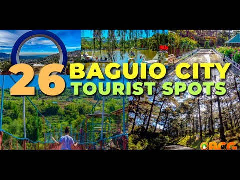
Baguio Landmarks and their History
Exploring the history behind a place adds a unique dimension to any travel experience. Baguio City, known as the “City of Pines,” is no exception, with its iconic landmarks holding fascinating stories. If you’re a curious individual who enjoys delving into the past, here’s a list of Baguio landmarks and their intriguing histories.
Mansion House and Wright Park
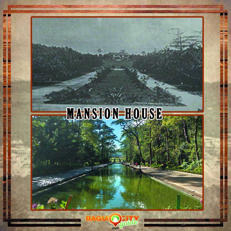
old photo from City of Pines (The Origins of Baguio as a Colonial Hill Station and Regional Capital) by Robert R. Reed
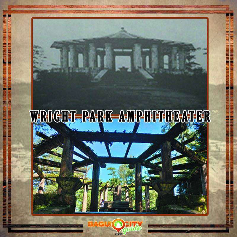
old photo from City of Pines (The Origins of Baguio as a Colonial Hill Station and Regional Capital) by Robert R. Reed
The original plan of the Mansion House included the lake drive with a large stone amphitheater at its end then a vast landscape garden now known as the Wright Park, named after Governor Luke E. Wright, an early proponent of Baguio’s development.The Mansion House, a grand structure built in 1907, holds significant historical value as it served as the official residence for American governors-general and continues to be the highland abode for Filipino Presidents. Named after Governor-General W. Cameron Forbes’ ancestral home, it was inspired by a residence located in Naushon Island off the coast of Massachusetts.
Teachers’ Camp
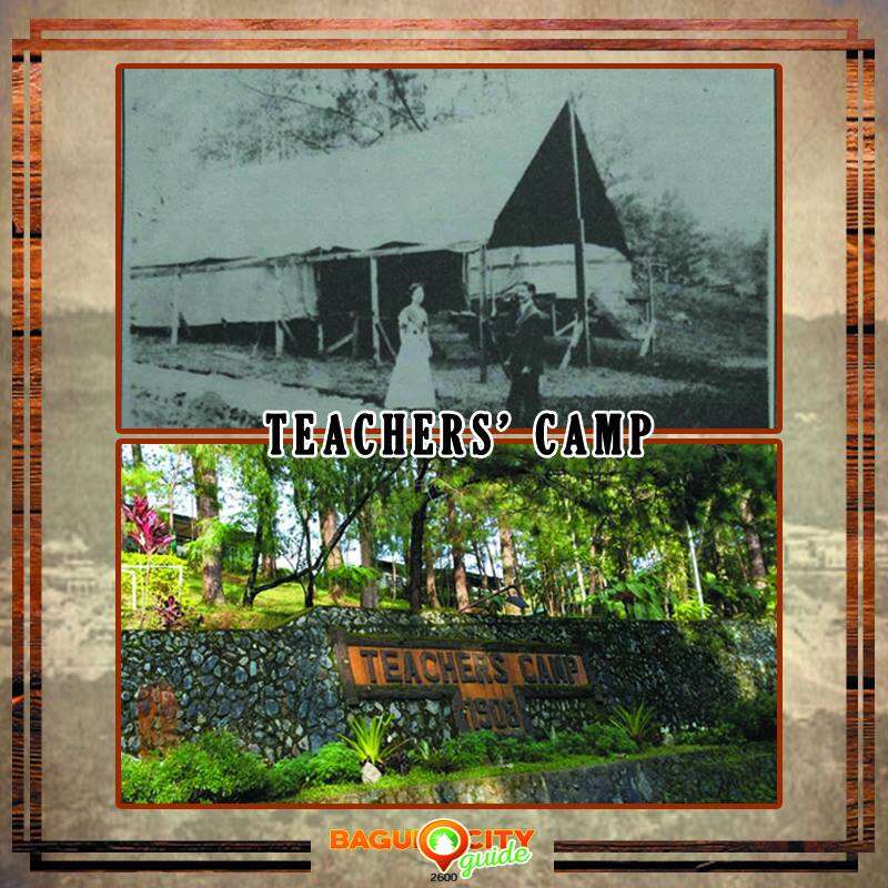
old photo from City of Pines (The Origins of Baguio as a Colonial Hill Station and Regional Capital) by Robert R. Reed
Teachers’ Camp traces its roots back to 1907 when Benguet Governor William Pack invited the Department of Instruction to hold their Teacher’s Assembly in Baguio. This assembly aimed to promote Baguio as the ideal summer capital and vacation resort. Over time, Teachers’ Camp became a beloved tradition, offering a serene getaway for educators to exchange knowledge, foster camaraderie, and recharge their spirits.
Camp John Hay

old photo from City of Pines (The Origins of Baguio as a Colonial Hill Station and Regional Capital) by Robert R. Reed
Read more: Camp John Hay Baguio Travel Guide
Burnham Park
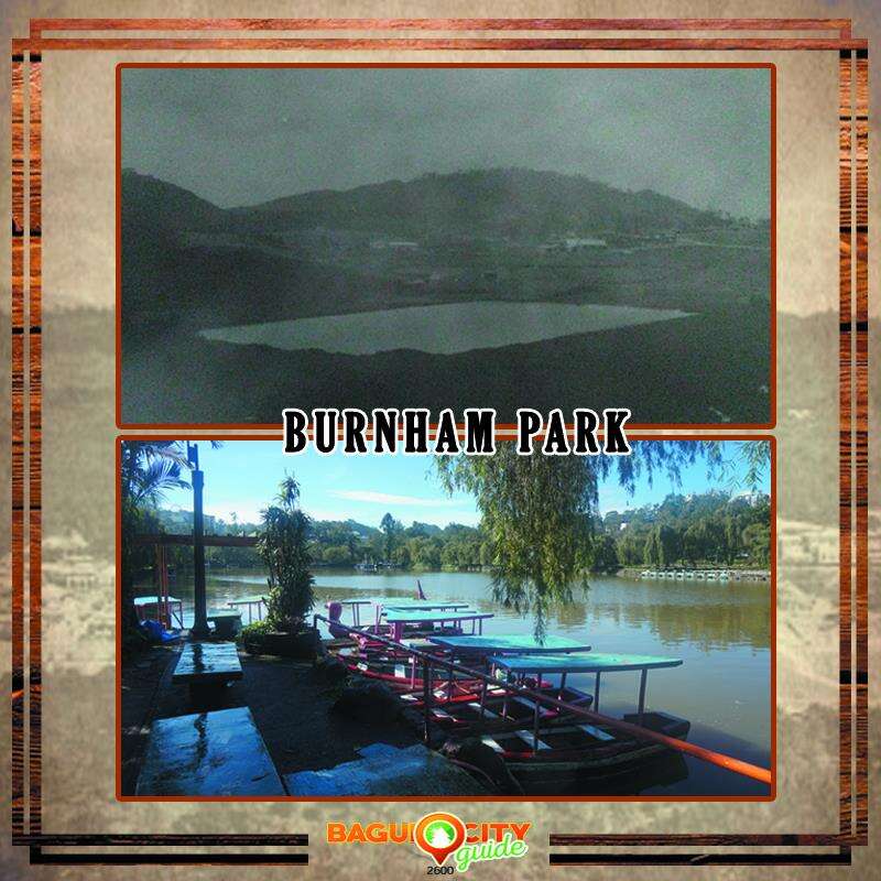
old photo from Baguio Museum Historical Photos
Burnham Park, named after the renowned American architect Daniel Hudson Burnham, has transformed significantly since its inception. The park’s original design included two small ponds that underwent changes in the 1930s. One pond was transformed into a skating rink, while the other became a ball ground, now known as the rose garden. The present-day lake at Burnham Park originated from the enclosed lagoon formed by Minak Creek, providing a tranquil and scenic spot for visitors to enjoy.
Kennon Road

old photo from Baguio Museum Historical Photos
Originally referred to as Benguet Road, Kennon Road’s construction began as a survey by the Philippine Commission to establish the most favorable railway route into Benguet’s mountainous region. Recognizing the potential of the area as a sanitarium and military post, Col. Lyman W. Kennon took charge of the project in 1903. Leading a diverse workforce of 4,000 men from 46 nationalities, Kennon succeeded in constructing the road that connected Baguio and Benguet, paving the way for the city’s accessibility and growth.
Bell Amphitheater
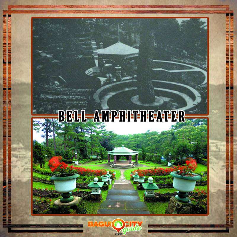
old photo from City of Pines (The Origins of Baguio as a Colonial Hill Station and Regional Capital) by Robert R. Reed
The Bell Amphitheater, a captivating venue within Camp John Hay, was built in 1913 and named after its designer, General J. Franklin Bell. Renowned for its architectural brilliance, the amphitheater follows the natural contours of the land and incorporates engineering methods practiced by highland tribes. Over the years, it has hosted numerous concerts, weddings, and public events, showcasing the rich cultural heritage of Baguio.
Baguio Country Club
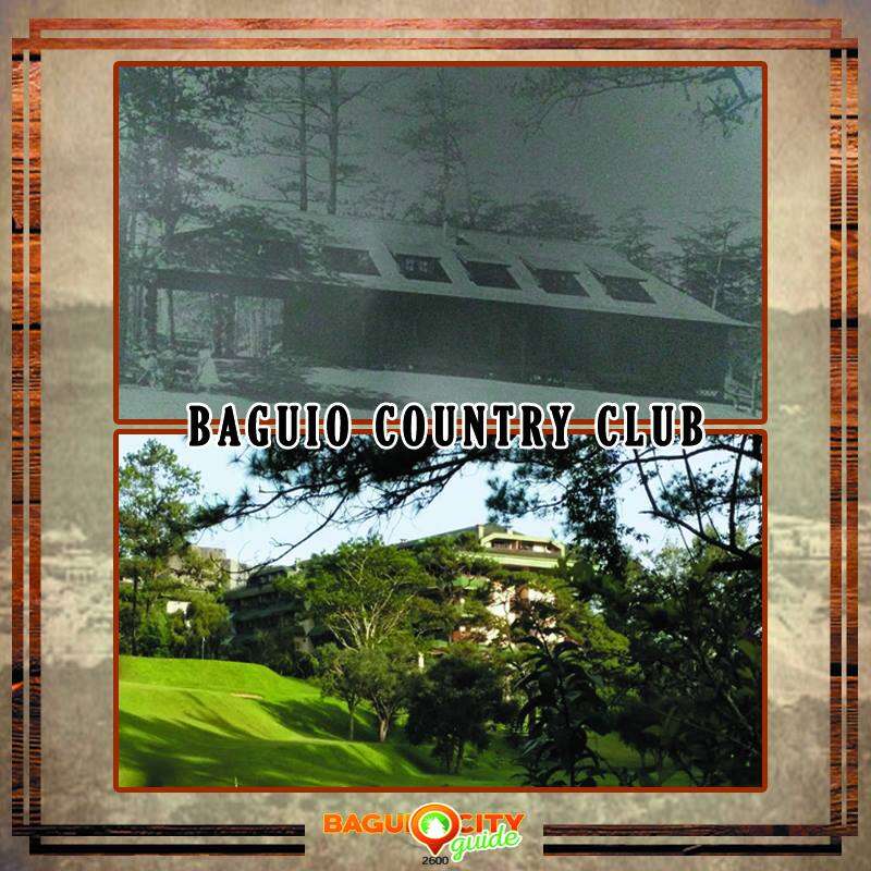
old photo from Baguio Museum Historical Photos
With a rich history dating back to 1906, Baguio Country Club initially operated from a grass-thatched, wooden slab structure. Over time, it transformed into a prestigious establishment, offering world-class amenities and recreational facilities. The club’s facilities expanded to include a three-hole golf course and a croquet course, attracting both local and international guests seeking relaxation and leisure in Baguio’s tranquil ambiance.
Governor Pack Road
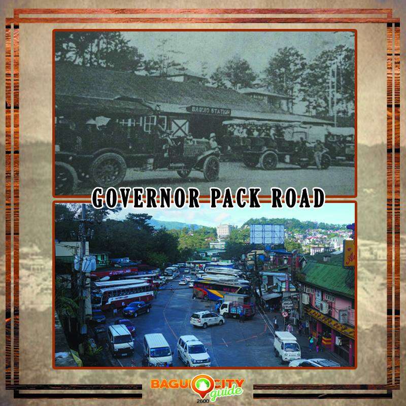
old photo from City of Pines (The Origins of Baguio as a Colonial Hill Station and Regional Capital) by Robert R. Reed. (Recent photo was taken before the pandemic)
Governor Pack Road, an important thoroughfare in Baguio, holds historical significance as it was once the location of the Benguet Auto Line Station. This station served as a hub for motorbuses transporting passengers to the Damortis rail station, facilitating connections to Manila. The road’s name pays tribute to Benguet Governor William Pack, who played a crucial role in the early development and promotion of Baguio as a favored summer retreat and vacation destination.
Maharlika Complex

old photo from City of Pines (The Origins of Baguio as a Colonial Hill Station and Regional Capital) by Robert R. Reed
The Maharlika Complex, now known as the Maharlika Livelihood Complex, stands on the grounds where the Stone Market once thrived. Constructed by German prisoners of World War I, the Stone Market was a bustling trading center where merchants and buyers converged. Despite enduring bombings during World War II, the Stone Market stood resiliently as a prominent landmark, surviving the ravages of time. Today, the Maharlika Livelihood Complex continues the legacy of commerce and serves as a vibrant hub for trade, showcasing the enduring spirit and resilience of Baguio’s people.
Know more and feel closer to Baguio
These Baguio landmarks hold significant historical value and reflect the city’s growth and development over time. By exploring their stories, visitors can gain a deeper appreciation for the rich heritage of the “City of Pines.” These landmarks showcase the city’s transformation from a mountain retreat loved by both locals and travelers alike.
See more news and updates like this one by exploring our Baguio City Guide website and by liking and following our official Baguio City Guide Facebook page.